From Steel Tapes to Plastic Wings: The Role of Drones and Photogrammetry in Collision Reconstruction

A collision reconstruction is only as good as the data it relies upon. It requires the use of the most accurate data available. However, investigators often face limitations, such as relying on low-quality scanned photos of vehicles or compressed videos recorded from a monitor using a cellphone. In any analysis relying on data, an adage applies: “garbage in, garbage out”. The same principle applies to nearly every field and aspect of forensic engineering, but is particularly relevant to those analyses dependent on the accuracy of field measurements.
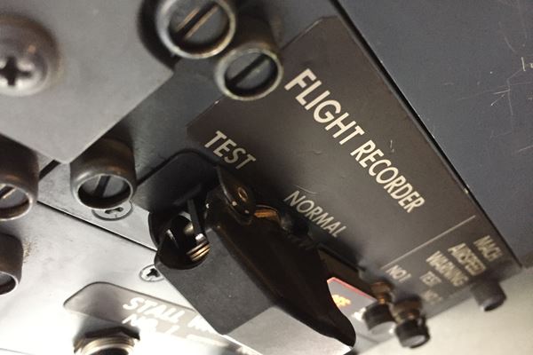
In the field of collision reconstruction, the lack of a clear and precise record of a collision scene or incident area can significantly alter the outcome of a case. Historically, appropriate documentation of an incident location involved hours of work with a steel tape, measuring wheel, or total station, oftentimes while navigating live traffic and playing real-life Frogger.
As technology evolved and satellites were sent into orbit, digital or robotic total stations and global navigation satellite system (GNSS) receiver-based systems greatly improved documentation efficiency, but the process still remained relatively labour-intensive and time-consuming.
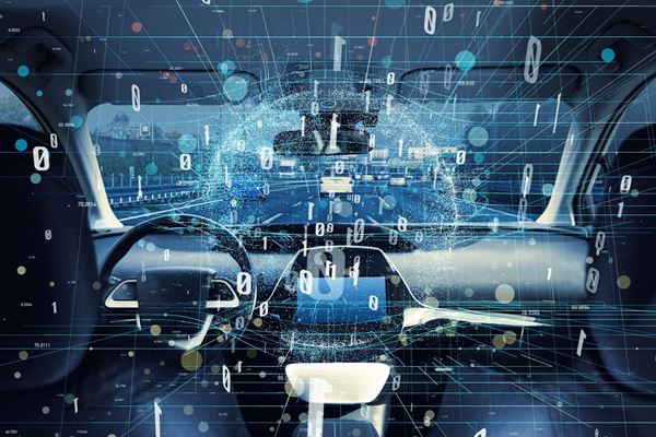
Today, Remotely Piloted Aircraft Systems (RPAS) or Unmanned Aircraft Systems (UAS), colloquially known as drones, are revolutionizing how investigators document and analyze collision scenes. With their ability to capture high-resolution imagery from above, drones offer unmatched speed, coverage, and accuracy. Their integration into the workflow of vehicle accident reconstruction (VAR) is not just increasing safety and convenience; it is transforming the industry and how collisions are analyzed.
Collision Scenes: Background
A collision scene is a dynamic environment. Vehicles are towed away, tire marks fade, debris gets cleared, fluid stains and scrape marks may be washed away, and temporary fixtures are removed (e.g., construction pylons or signage). Physical scene evidence lays the groundwork for determining the location of the collision on the roadway (e.g., which vehicle crossed the centreline, interaction with roadside objects), the post-impact movements of a vehicle (e.g., how it rotated or rolled after a collision), and the sightline between involved drivers. Once that physical evidence is gone, it can never be recovered.
In criminal cases, police investigators are typically able to close roadways and collect comprehensive data. A trained police reconstructionist may spend hours photographing, measuring, and documenting a collision scene. However, the involvement of an officer trained in collision reconstruction is usually reserved for major collisions involving fatalities or life-threatening injuries. In cases where injuries are moderate or less, the scene documentation is usually limited to a handful of photographs (and no measurements), whether captured by a detachment officer or by one of the involved drivers or passengers.
In civil cases, it is unlikely that an accident reconstruction expert will attend a collision scene before the vehicles have been towed and the roadway has been reopened. More often than not, we get involved a few years afterwards, when the vehicles have been disposed of and the roadway evidence has long been erased. In these types of cases, we rely heavily on the information captured by people at the scene, whether it’s a fatality incident with a full set of measurements and photographs collected by a police reconstructionist, or a moderate collision with two photographs captured on a bystander’s smartphone.
How Drones Have Revolutionized Civil Collision Reconstruction
In these common civil scenarios, where photographic evidence exists but measurements don’t, drones offer a crucial advantage through the use of photogrammetry. Photogrammetry is the science of making reliable measurements, maps, or 3D models from photographs. Although the concept of photogrammetry has been around since the 19th century, it has become more accessible and practical in the last decade, due to the affordability and commercial availability of drones.
Photogrammetry using drones involves taking advantage of their ability to quickly and consistently capture photographs. Drones equipped with high-resolution cameras can be used to fly a grid-like pattern, capturing a sequence of overlapping aerial photographs with consistent altitude, orientation, and image overlap (typically 70-80%). The overlap is necessary to ensure that distinguishable and unique features (e.g., posts, lane lines, curbs, sidewalk joints, fluid stains) are visible in multiple images from different vantage points. Once the area of interest has been sufficiently photographed, the images are processed in specialized photogrammetry software that aligns the images, identifies common points, and uses algorithms such as Structure from Motion (SfM) to reconstruct the scene in 3D. The result can vary depending on the goal of the project, but in collision reconstruction, the two outputs are typically a point cloud and an orthomosaic image.
A point cloud is a dense collection of individual 3D points, each with spatial coordinates and color, representing the shape and surface details of an object or scene. An orthomosaic image is a high-resolution, geometrically corrected aerial photograph created by stitching together multiple overlapping photographs with uniform scale and no perspective distortion.
Where Photogrammetry Plays a Role
As previously mentioned, drones are being used more frequently in collision reconstruction due to the photogrammetric products they can create. The value of photogrammetry in collision reconstruction lies in its ability to support reverse projection, a forensic technique used to determine the position, orientation, and height of a camera based on visual scene matching of a photograph or video frames. Historically, reverse projection has been used by agencies such as the FBI for suspect height analysis, but it is also commonly used in modern collision reconstruction.
Through reverse projection, a 2D photograph can be aligned within a 3D environment, and investigators can accurately project the location of physical evidence, like tire marks or debris, into the reconstructed 3D environment. Even when the drone flight occurs years after a collision, locations of pertinent evidence such as tire marks, fluid stains, or construction pylons can be transferred into an appropriately scaled 3D representation, as long as there are identifiable and unchanged objects visible in both the scene photograph and the drone model (e.g., lane lines, sewer grates, curb lines, asphalt cracks or sidewalk expansion joints, etc.). Matching these common points enables the software to recreate the original camera view and project scene elements in proper scale and perspective.
In this manner, a single photograph from several years prior can be used to determine the rest positions of vehicles, the length of a tire mark, or the location of a gouge mark. When a few extra inches of braking distance can make the difference in calculating whether a striking vehicle was speeding or not, drone photogrammetry and reverse projection can completely alter the outcome of a collision analysis.
Without reverse projection, investigators must rely on subjective visual estimates, which are prone to geometric distortion and scrutiny, as they do not account for camera perspective (or zoom), lens distortion, elevation changes, parallax errors, or other geometric changes that can substantially alter the apparent size and position of objects in a 2D image.
Apart from reverse projection, photogrammetric solutions from a drone are also valuable as an underlay to complement police scene measurements and diagrams or to create a virtual 3D environment for visualizing driver perspectives and sightline obstructions (such as around a retaining wall at an intersection).
Advantages of Drones in Collision Reconstruction
Although drones are excellent for their applicability in photogrammetry and reverse projection of 2D evidence into 3D environments, they also offer other advantages over traditional scene measurement techniques.
- Speed: A drone can typically capture a photograph set from a multi-lane highway or intersection in less than 30 minutes, while traditional measuring wheel, total station, or GNSS surveying methods might take several hours (depending on the amount of traffic).
- Accuracy: Although total stations and GNSS receivers offer centimeter-level accuracy, this is not lost when utilizing drone photogrammetry. When paired with ground control points (GCPs) in the form of identifiable targets measured with an RTK system, drone solutions offer similar centimeter-level precision.
- Presentability: Drone imagery produces high-resolution, up-to-date visuals, offering a far more meaningful backdrop than a low-resolution, decade-old satellite image from a public database.
- Safety: Collision investigators can operate from the roadside or even outside the roadway or area entirely, minimizing exposure to traffic or environmental hazards.
- Cost: 3D point clouds for reverse projection analyses can also be created using terrestrial 3D scanners, but these scanners are significantly more expensive and much less portable than a drone. In most cases, a drone appropriate for point cloud and orthomosaic generation can cost as little as $500.
- Versatility: Drones can operate on the least forgiving of terrain, including steep embankments, dense vegetation, and across bodies of water. Proper overlap of images allows for documentation and analysis of slope profiles and contours in areas where access would otherwise be difficult (or impossible).
- Views: Drones allow the capture of both oblique and nadir images from various heights, offering comprehensive views of the collision environment and/or highlighting vantage points that wouldn’t otherwise be available.
Case Study: Tractor-Trailer Rollover
A single-vehicle rollover occurred at an inner-city interchange. The rolled vehicle was a standard 6x4 tractor that was towing a loaded 40’ C-can 2-axle trailer. The incident occurred when, while maneuvering a left turn at an intersection, the tractor-trailer rolled onto its right side, coming to rest along the right shoulder of the adjoining road that it was turning onto.
As it was a relatively low-severity rollover, a police reconstructionist did not attend or document the scene. A set of scene photographs was captured by the driver and provided to Envista, but there were no measurements or accommodating information. Within the set of photographs, there was a visible tire mark that appeared to extend from the near edge of the intersection to the rear axle of the trailer. This tire mark was of particular interest to Envista, as it traced the path of the trailer’s outer wheel end during initial lift-off of the inner wheel end and eventual rollover. The objective of our analysis was to project the tire mark seen in the 2D photograph into a 3D environment, so that simulations could be performed to determine the tractor-trailer’s turn path and its rollover speed.


A drone flight was completed around the intersection and the surrounding roadways, and a total of nearly 950 images were captured to document the area of interest. Then, a photogrammetry analysis was completed using the set of drone photographs, and both a 3D point cloud and an orthomosaic image were generated.
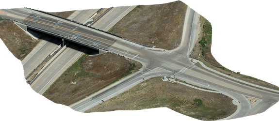
Figure – 3D Environment (point cloud result)
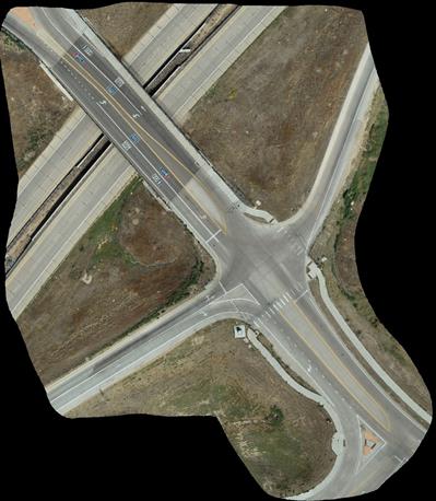
Figure – Orthomosaic Image
Using specialized collision reconstruction software, camera matching and reverse projection analyses were performed on each scene photograph that captured the tire mark of interest. The locations of identifiable scene features, such as crosswalk line edges, delineator posts, power poles, and lane lines, were used to accurately recreate the original camera positions. Representative 3D vehicle models were placed into the 3D environment and aligned with the view of the rolled tractor-trailer to estimate its final rest position on the shoulder. The tire mark from the 2D photographs was projected onto the 3D road surface, allowing its curvature to be traced and measured. This provided an estimated path of travel for the trailer’s outer wheel end, which was then used to simulate the rollover event with high precision. Such precision was essential to determining the tractor-trailer’s path and speed, and to assessing whether it was travelling above or below the safe speed for the turn, given the geometry of the vehicle combination.

Figure – 3D scene with reconstructed vehicle rest position.

Figure – 3D scene with reconstructed vehicle rest position and projected view from 2D photograph showing the tire mark.

Figure – 3D scene with reconstructed vehicle rest position and projected view from 2D photograph, with a red trace for the tire mark.
From the days of steel tape to today’s drone photogrammetry, the evolution of scene documentation has been nothing short of dramatic. Drones provide investigators with a fast, accurate, and safe method to document incident sites while offering perspective and clarity to the end product that ground-based methods simply cannot match.
When used correctly, drones don’t just document a collision scene; they preserve it, enabling investigators, courts, and clients to revisit it long after the physical evidence has disappeared. As technology continues to advance, drones are poised to become as standard in collision investigation as the total station once was.
Nuestros consultores están listos para ayudar.